 New York can be daunting. You come over that hill in the cab from JFK and see the city sprawled out in front of you and can't help but feel a little intimidated. Here are my basic essential tips for navigating the city.
Take the train from JFK and Newark.
Take a cab from Laguardia. JFK and Newark both have train stations within the airport linking you directly to the city. Take either one towards Penn Station (tho don't get off at Newark Penn Station if you're coming from Newark). Laguardia is connected by public transportation, but requires riding a Queens bus and then a train to get to Manhattan and can be a tricky transfer to make, so cough up the $20 and take a cab into town, or at least to the closest train station.
 Your Subway metrocards work on the subway and the bus system. Use both! Buy an unlimited metrocard if you're staying for more than 5 days. The weekly unlimited car is absolutely worth it as long as you take the subway or a bus twice a day.
Do not take a pedi-cab. Ever. (Ed. note: Okay, okay, okay. Like Emily says in the comments below, if you're not in a hurry and it's a nice day, a pedi-cab can be fun. I guess my advice is don't take a pedi-cab if you have time constraints, if the weather is bad or if you are wanting to get somewhere quickly.)
When you’re on Manhattan, only take yellow colored taxis. The black limousine services will try to negotiate a price with you rather than charging the standard $0.40 per 1/5 mile and they target tourists and people at the airports. Don’t be fooled by the guys who offer to take you to the city for $50/60/70 outside JFK. If you wait in line and take a yellow cab, it’s a standard $45 to Manhattan. No matter where you’re going.
When planning your in-town traveling...
Keep in mind that transfers add lots of time to your trip. If you only have a few stops to go on a new train, sometimes walking can be quicker than making a transfer. Also keep in mind that traveling cross-town, especially in cabs, can take ages and often times, it’s a lot quicker to walk the long blocks than it is to ride in a cab. This is not the case late at night when cabs have relative free range and trains are running on night schedule. Some trains after midnight only run once every 30 minutes, and let me tell you, waiting 30 minutes in a subway tunnel drunk and with 30 other drunk strangers is not fun. On that note, falling asleep on trains late at night is also unadvised.
Pack an umbrella, tennis shoes and a jacket no matter what time of year it is or what the weather says. Sometimes it just rains in New York, and you will be one of the few without umbrellas if you don't have one (and will be forced to buy a $20 one that breaks instantly off one of the many street vendors that pops up). You will walk everywhere and should be prepared for that. If you can walk 5 miles in heels, go for it. But don't whine coz that's annoying. It can also get pretty windy in the city and especially at night, even in the dead heat of summer, it can get chilly on rooftop bars, while walking outside or on the rivers (think booze cruises and ferries).
Don't discount the other boroughs. 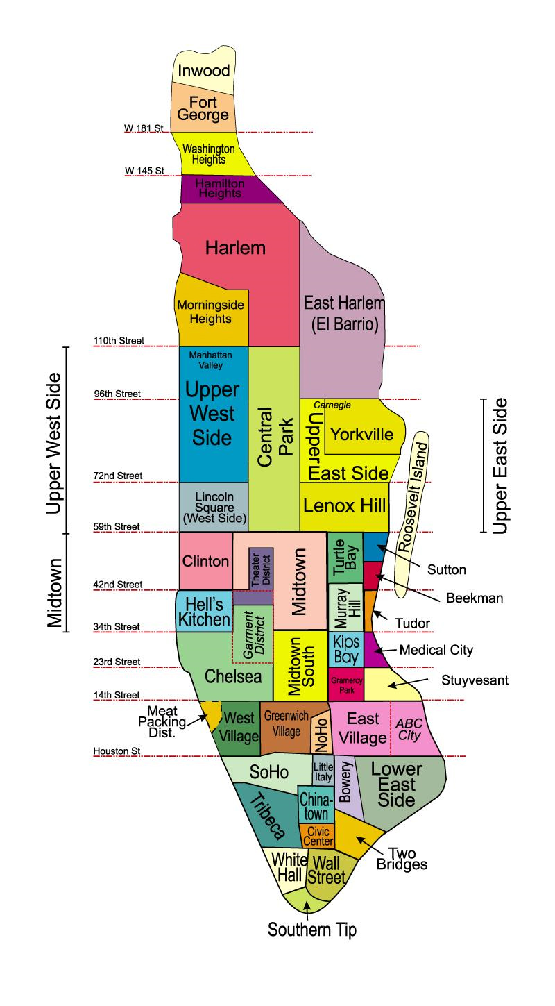 **Click Map for Larger Version**
Manhattan is great. But there are lots of things to see and do in Queens, Brooklyn, the Bronx and Staten Island. Don't feel confined to the island and do get out and experience the rest of the city.
Study your neighborhoods.
Just having a basic understand of major street structure and where neighborhoods are can help you navigate tremendously. Numbered Avenues run North South and start in the East getting bigger towards the West. Numbered Streets run East West and start at Houston (pronounced How-sten, not like the city Hyew-sten) and get larger as you go North. The streets south of Houston get a little complicated so don’t worry about them. That's what Google Maps is for, right?
Speaking of Google Maps. My favorite free phone apps you can use to navigate the city. Google Maps is obvs. Give it your starting and ending destination and pick "public transportation" and it will plot all the trains and busses you need to change around including up to date info about train construction and stop/line changes. If you want a subway specific map, KICKMap Lite (iTunes link) is a great free iPhone app for studying your subway maps without leaning over someone in a car. Living Social (iTunes link) and Groupon (iTunes link) have HUGE discounts and several coupons daily in NYC. Thrillist, Yelp and Urbanspoon are great ways to find restaurants, bars and things to do.
Got any other NYC tips yourself? Add them in the comments and I’ll append them to the article!
Amazing photo by Christopher Schoenbohm of www.LostManProject.com